 |
Israel in the Middle East
|
 |
| Israel and bordering states. The United Arab Republic is Egypt |
 |
| Threats to Israel |
Sykes-Picot Agreement
 |
| A 1916 map of the Middle East showing French (“A”) and British (“B”) areas of control, according to the secret Sykes-Picot agreement. Sir Mark Sykes, the Middle East adviser to the secretary of state for war, Lord Kitchener, signed the Sykes-Picot agreement with the French diplomat Francois-Georges Picot. |
 |
| Sykes-Picot agreement |
Balfour Declaration - November 2, 1917
This is a letter from the United Kingdom's Foreign Secretary Arthur James Balfour to Baron Rothschild (Walter Rothschild, 2nd Baron Rothschild), a leader of the British Jewish community, for transmission to the Zionist Federation of Great Britain and Ireland.
His Majesty's government view with favour the establishment in Palestine of a national home for the Jewish people, and will use their best endeavours to facilitate the achievement of this object, it being clearly understood that nothing shall be done which may prejudice the civil and religious rights of existing non-Jewish communities in Palestine, or the rights and political status enjoyed by Jews in any other country.
The text of the letter was published in the press one week later, on 9 November 1917. The "Balfour Declaration" was later incorporated into the Sèvres peace treaty with the Ottoman Empire and the Mandate for Palestine. The original document is kept at the British Library.
Peel Commission


Peel Commission Partition Plan, July 1937
Left and above
On July 7, 1937, the (Lord) Peel commission
published a report that, for the first time, stated that the British Mandate
had become unworkable and recommended a partition. Chaim Weizmann made a speech
on behalf of the Jews. The Mufti of Jerusalem, Hajj Amin al-Husseini, testified
in front of the commission, opposing any partition of Arab lands with the Jews.
He demanded full cessation of Jewish immigration. The Jewish leadership
accepted the partition in principle as an opportunity for sovereignty, while
"most of the Arabs" condemned the Plan.
Ben-Gurion wrote 20 years later:
"Had partition (referring to the Peel Commission partition plan) been
carried out, the history of our people would have been different and six
million Jews in Europe would not have been killed—most of them would be in
Israel".
Cease Fire Lines 1949

Palestine
Published on YouTube Dec 24, 2013
Watch Ambassador Danny Ayalon as he rebuttals to "The real Truth about Palestine"
"Palestine was the Greco-Roman name for a region. In the year 135 AC, the name of the region became the official name of one of the provinces of the Roman Empire in an attempt to obliterate the connection between the Jewish people and Judea - the land they've inhabited for over 1000 years.
However, like Antarctica, the Amazons or the Sahara, naming a place doesn't create a nation of Antarcticans or Saharans.
Oh, and for the record, Jesus was not a Palestinian, he was a Judean Jew."
Between the years 1949 and 1967, the Kingdom of Jordan ruled the Judea/Samaria highlands. Israel's 'waistline' in the Sharon region was extremely narrow, totaling a mere 15 km (9 mi.) in the area of Tulkarm and Netanya. These were cease-fire lines rather than permanent borders, and were considered to be indefensible, especially in light of the area's topography, which left Israel in the plains while the Arab armies controlled the dominating high ground. The Israeli Foreign Minister at that time, Abba Eban, used to describe these lines as 'Auschwitz boundaries', in order to illustrate the dangers inherent in their continued use.
 |
Israel's narrow 'waistline'
|
The Six Day War 1967
The Six Day War was the first major Arab attempt since 1948 to destroy Israel. In November 1966, an Egyptian-Syrian Defense Agreement was signed, encouraging the Syrians to escalate tensions, which reached a climax in the spring of 1967.
- May 14: Egypt mobilizes its forces in and around the Suez Canal.
- May 16: Egypt moves it forces eastward across the Sinai desert towards the Israeli border, demanding the withdrawal of UN Emergency Force (UNEF) stationed along the frontier.
- May 19: The Egyptians expelled the UN Emergency Force (UNEF) from the Gaza Strip and Sinai, and continued pouring its military forces into these areas.
- May 22: Egypt closed the Straits of Tiran to Israeli shipping, constituting a casus belli for Israel.
- May 24-June 4: Answering the Egyptian call, the governments of Jordan, Iraq, Saudi Arabia, Syria and Lebanon moved their forces toward the Israeli border. Israel mobilized its reserve forces, and launched a diplomatic campaign to win international support for ending the Egyptian blockade of Israeli shipping through the Strait of Tiran.
 |
| Events Leading to the Six Day War 1967 |
Once it became clear that the diplomatic campaign had failed, and following Jordan's participation in the Egyptian-Syrian alliance, Israel launched action in self-defense against the massing threat from Egypt on June 5, 1967. Once Jordan and Syria initiated the fighting against Israel, the war also included those countries. In the course of the war, the Israeli forces captured the Sinai peninsula, reaching the Suez Canal, and captured the territories of Judea and Samaria as well as the Golan Heights - from which the Syrians had shelled Israel.
 |
| Israel after the Six Day War 1967 |
 |
| Jerusalem after the Six Day War 1967 |
Jerusalem
 |
| Jerusalem before and after 1967 |
 |
| Jerusalem, the old city |
The Yom Kippur War - October War
October 6 to 25, 1973
The war began when the Arab
coalition launched a joint surprise attack on Israel on Yom Kippur, the holiest day in Judaism, which occurred
that year during the Muslim holy month of Ramadan. Egyptian and Syrian
forces crossed the ceasefire lines to enter the Sinai Peninsula and Golan
Heights respectively, which had been captured by Israel in the 1967 Six Day
War.
 |
| (a) Left 6 - 13 October (b) Right 14 - 15 October |
 |
| (a) Left 15 - 17 October (b) Right 18 - 23 October |
The war
began with a massive and successful Egyptian crossing of the Suez
Canal. After three days, Israel had mobilized most of its
forces and managed to halt the Egyptian offensive. The Syrians coordinated their attack on the Golan Heights to coincide with the Egyptian offensive and initially
made threatening gains into Israeli held territory. Within three days, however,
Israeli forces had managed to push the Syrians back to the pre war ceasefire
lines. They then launched a four day counterattack deep into Syria. Within
a week, Israeli artillery began to shell the outskirts of Damascus. In the Sinai Israel counterattacked at the seam between the two
Egyptian armies, crossed the Suez Canal into Egypt, and advanced southward and westward towards Cairo reaching within 101 kilometers (63 miles) of Cairo and completed the encirclement of Egypt's Third Army
and the city of Suez.
 |
| Golan Hights Campain: (a) Left 6 - 10 October (b) Right 11 - 12 October |
The war had far reaching
implications. The Arab World, which had been humiliated by Israel victory in
the Six Day War (1967), felt that their honor was regained by the early successes in the
conflict, yet the end result of the war brought them to the realization that Israel
cannot be destroyed. This psychological shift of thinking is part of the
reasons that led to the signing of the first peace treaty between an Arab
nation, Egypt, and Israel in 1978. Egypt which pulled away from the Soviet Union influence, created a shift in balance between the two superpowers and a major change in
the region.
 |
| October 25 ceasefire and the encirclement of Egypt`s Third Army (red) and the city of Suez |
The Golan Hights
 |
| The Golan Heights |
The Golan Heights are strategically important for several reasons:
- (a) Israeli presence in the Golan Heights provides a defensible border against invasion by land;
- (b) All of northern Israel is within range of direct artillery fire from the Golan Heights;
- (c) The Heights control the main water sources of the State of Israel.
 |
| The Golan Heights cross section |
The West Bank
Based on agreements reached between Israel and the Palestinians in the 90s, arrangements for Palestinian self-government were established. The Palestinians rejected the proposals made at the Camp David Summit of July 2000, which would have resulted in the establishment of a Palestinian state in most of Judea and Samaria (as well as in the Gaza Strip). The Palestinians followed their rejection with a bloody terror campaign. Israel in 2003 accepted the Roadmap which would lead to the establishment of a Palestinian state alongside Israel, provided the Palestinians fulfill their obligations to end terrorism and incitement. The final status of Judea and Samaria - determining the borders between Israel and the Palestinian state, and those parts of Judea and Samaria which are to be correspondingly under Israeli and Palestinian jurisdiction - is yet to be resolved and is currently the subject of negotiations between the Government of Israel and the Palestinian Authority.
 |
| Disengagement Judea and Samaria |
The West Bank
Uploaded to YouTube on Jul 12, 2011
Israel's Deputy Minister of Foreign Affairs Danny Ayalon explains the historical facts relating to the Israeli Palestinian conflict. The video explains where the terms "West Bank", "occupied territories" and "67 Borders" originated and how they are incorrectly used and applied.
The Gaza Strip
About twice the size of
Washington DC, with a population of 1.6 million, with 40 kilometer of coastline (Mediterranean Sea), and 13 kilometer border with
Egypt.
After World War I, the Gaza area
became part of the British Mandate of Palestine, and it was occupied by Egypt
in 1948, in the aftermath of the first Arab-Israeli war.
Israel took control of the region for the first time during the Six-Day War in 1967, along with the West Bank, eastern Jerusalem,
the Golan Heights, and the Sinai Peninsula.
In 1994, Israel withdrew from
parts of the Gaza Strip as part of its obligations under the Oslo Accords
(which also affirmed the rights of the Palestinians to self-government). The
Palestinian National Authority and Israel shared power in the Gaza Strip for
the next 10 years, with the PNA administering civilian control and the Israelis
overseeing military affairs as well as the borders, airspace, and remaining
Israeli settlements.

The disengagement from Gaza
The disengagement was the withdrawal of the Israeli army from
Gaza, and the dismantling of all Israeli settlements (Blue - Map below) in the Gaza
Strip in 2005. Four small settlements in the northern West Bank were
also evacuated.
The disengagement was proposed by Israeli
Prime Minister Ariel Sharon, adopted by the government on June 6, 2004 and
enacted in August 2005. Those Israeli citizens who refused to accept government
compensation packages and voluntarily vacate their homes prior to the August
15, 2005 deadline, were evicted by Israeli security forces over a period of
several days. The eviction of all residents, demolition of the residential
buildings and evacuation of associated security personnel from the Gaza Strip
was completed by September 12, 2005. The eviction and dismantlement of the four
settlements in the northern West Bank was completed ten days later.
* In 2007, Hamas seized control of the Gaza Strip,
causing a division between the region and the other Palestinian territory, the
West Bank, where the Fatah (PLO) party is dominant. In 2014 the Hamas and the
PLO reached a Unity PNA Government agreement.

In these two UN maps (PDF) of Israel, and the East Mediterranean notice that the Gaza Strip is a part of Egypt.
The peace treaty between Israel and Egypt (March 26, 1979), who did not claim back the Gaza Strip (occupied by Egypt in 1948) created a strange situation were Gaza does not belong to any country. The town of Rafah (Rafiach) which grew under Israeli control across the International border is divided, part in Egypt and part in Gaza. The Philadelphie Barrier (Oslo Accord) runs along the street "Al Tarik Al Hadidi" designated as the international border.

For more about Gaza: https://www.cia.gov/library/publications/the-world-factbook/geos/gz.html
The peace treaty between Israel and Egypt (March 26, 1979), who did not claim back the Gaza Strip (occupied by Egypt in 1948) created a strange situation were Gaza does not belong to any country. The town of Rafah (Rafiach) which grew under Israeli control across the International border is divided, part in Egypt and part in Gaza. The Philadelphie Barrier (Oslo Accord) runs along the street "Al Tarik Al Hadidi" designated as the international border.
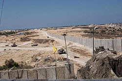 |
| Construction of the Philadelphie Barrier |
Who Occupies Gaza?
Columbia University Library, Map Collection
CIA
Department of History, U.S. Military Academy
CIA
Department of History, U.S. Military Academy
Koret Communications, IL
Copyright © 2014 Joseph Yossi Greber, All rights reserved.
This material is intended for educational use only.
I rely on the fair use of this website.
© כל הזכויות שמורות
No comments:
Post a Comment
Note: Only a member of this blog may post a comment.